|
Introductory and Advanced Habitat Survey of the Woodens River Watershed Prepared by the Woodens River Monitoring Technicians Roxanne Bower Kim Fougere Mike LeBlanc July 4 — September 1, 2000 Halifax County, Nova Scotia
Organization: Nova Scotia Department of the Environment—Nova Scotia Youth Conservation Corps Community Partner: Woodens River Watershed Environmental Organization Volunteer Supervisor: Jim Holmes
Acknowledgements: *1.0 Introduction *2.0 Materials and Methods *2.1 Module 1: Introductory Stream Habitat Survey *2.2 Module 2: Advanced Stream Habitat Survey *2.3 pH Monitoring *2.4 Module 4: Stream Invertebrates Survey *2.5 Module 11: Juvenile Fish Trapping and Identification *3.0 Results *3.1 Module 1: Introductory Stream Habitat Survey *3.1.1 Stream A; Five Island Lake Run *3.1.2 Stream B; Flake Brook *3.1.3 Stream C; Frederick to Five Island Lake *3.1.4 Stream D; Sheldrake to Five Island Lake *3.1.5 Stream E; Hubley Big to Long Lake *3.1.6 Stream F; Birch Hill Lake Feeder Stream *3.1.7 Stream G; Black Point to Fredrick Lake *3.1.8 Stream H; Arnold’s Little Lake to St. Margaret’s Bay *3.1.9 Stream I; Dolly’s and Old Mill Pond *3.1.10 Stream J; Old Mill Pond to Albert Bridge Lake *3.1.11 Stream K; Gates and Millyard Lake *3.1.12 Stream L; Crouchers and Gates Lake *3.1.13 Stream M; Long to Crouchers Lake *3.2 Module 2: Advanced Habitat Survey *3.3 pH Monitoring *3.4 Module 4 Stream Invertebrate Survey *3.5 Module 11: Juvenile Fish Trapping & Identification *4.0 Public Response *4.1 General Response from Public *4.2 Presentations *5.0 Discussion and Recommendations *6.0 Conclusions *7.0 Appendixes *7.1 Appendix A; Map of Watershed *7.2 Appendix B; Module 1 *7.3 Appendix C; Module 2 *7.4 Appendix D; ph Monitoring *7.5 Appendix E; pH Monitoring (ordered) *7.6 Appendix F; Module 4 *7.7 Appendix G; Module 11 *
Nova Scotia Department of the Environment Heather Gordon (Coordinator, NSYCC) Jacob McIntyre (Support Staff, NSYCC) Woodens River Watershed Environmental Organization Jim Holmes (Supervisor) Bob Chambers Richmond Campbell Frank Hope Don Black Joe Lauder Community Members Pat Donoghue
In the summer of 2000, the Woodens River Watershed Environmental Organization (WRWEO) employed three youth to conduct baseline habitat and water quality studies of streams throughout the watershed. Funding was supplied through the Nova Scotia Youth Conservation Corps, a program within the Department of the Environment, councilors Reg Rankin and Jack Mitchell, and the Three Brooks Development Corporation. The Woodens River watershed consists of an area of 65 Hectors (16000 acres) and encompasses 19 connected lakes. These lakes extend from Cranberry and Upper Sheldrake, down through Long and Crouchers lakes and it continues until it drains into St. Margaret’s Bay at Woodens Cove in Seabright (refer to appendix A for map of the watershed). The WRWEO’s community management plan consists of "promoting environmentally responsible and economically sustainable development of the watershed"1. This project will help to facilitate this plan by providing data that will be used as a starting point for future habitat and water quality monitoring. In addition, the project will provide valuable information in order to help make informed decisions about current and future actions in the watershed including residential development, logging, and recreation. One of the project goals was to provide primary and advanced habitat assessments to provide current information on the health of the streams in the watershed. By doing these baseline studies now, the impact from human practices and development can be monitored through future studies. The second project goal was water quality monitoring. Monitors set up permanent monitoring stations to test pH, where it can continue to be tested in the future. Fish and invertebrate surveys were conducted in several streams to give a further indication of water quality. The last goal was to provide community education and awareness concerning human impacts on the watershed. The project was carried out through the use of the Pacific Streamkeepers Federation Handbook, which was issued by Department of Fisheries and Oceans in British Columbia. The handbook provided detailed survey instructions for each module. The modules used in this project included the Introductory Stream Habitat Survey (Module 1), the Advanced Stream Habitat Survey (Module 2), the Stream Invertebrate Survey (Module 4) and the Juvenile Fish Trapping and Identification Module (Module 11). This surveying package was used because it required in depth analysis of the watershed and was directed to volunteer organizations. Additional information on the streams was also collected through use of the stream survey form (7.13) that is provided through the Adopt-A-Stream program.
1 WRWEO Management Plan; - This document was produced in 1998; it is available on request - DP, Oct 31, 2010
Module 1 consisted of an introductory stream habitat survey. Information pertaining to various streams in the watershed was collected. Important features as well as habitat problems and opportunities for habitat improvement were noted. Thirteen streams were surveyed. The streams were identified using a Topographical Map (11 D/12) with a 1:50 000 scale. Stream codes were assigned alphabetically in the order that they were surveyed (refer to appendix 1 for watershed map). The stream was surveyed by selecting a start point at the downstream end and measuring the distances to significant landmarks (bridges, culverts and roads) as well as other notable features (logging activity, heavily impacted areas and garbage). Two to four channel dimensions of typical cross sectional areas of the stream were measured following the criteria set forth in Module 1. These measurements were taken in order to determine the average channel dimensions to be further used in Module 2 for the longitudinal survey. The dimensions (bankfull & wetted channel width and depth) were taken using a 60 m measuring tape and a meter stick. An upstream end point was determined and the precise directions to the start and end points were recorded. The start and end points were marked in association to a fixed landmark, so they could be located in future years. Unmapped features were recorded and identified on the Stream Feature Description Checklist-(appendix 3 of Streamkeepers Module 1) and the surveying data was recorded on the data sheets that were provided with the module. Module 2, was performed on seven of the thirteen surveyed streams (C, E, G, H-K). This module was undertaken in order to elaborate on important stream conditions and habitat information, which was already collected in the previous survey. One reference site from each stream was chosen as a benchmark and marked using flagging tape, a marker, and a nail. The precise directions to the benchmark were recorded on the data sheets provided. At each site, cross sectional and longitudinal surveys were conducted as well as stream discharge and a general habitat assessment according to the directions in module 2. Data was collected and recorded on the field data sheets provided in Module 2. Permanent monitoring stations were selected at various streams. After initial pH measurements, additional measurements were taken following a substantial change in weather conditions (ie. heavy rainfall). Other factors recorded included: time, air & water temperature, weather conditions, stream flow and stream color.
Module 4 was conducted on four streams: A, C, G and K. This survey was performed in order to assess the overall health of the stream. This survey was a good indicator of water quality because certain species thrive in streams with low pollution levels (mayflies, stoneflies and caddisflies), while other species (leaches, blackfly larvae and aquatic worms) are pollution tolerant. Therefore the presence or absence of specific species give an extremely good indication of the current water quality. Three invertebrate samples were collected within the longitudinal survey section of module 2 using a 30.48 x 30.48 cm Surber Sampler-Net (563 m m) with a one square foot sampling area. The net was placed facing upstream and the rocks within the sampling area were scrubbed clean, while the current carried the invertebrates into the net. Upon completion, the contents of the net were transferred into a pan and sorted into ice-cube trays for identification. Species were identified to the family level through use of the taxonomic key provided. The locations of the sampling areas as well as the number of invertebrate families were recorded. Additional calculations in the field sheets were completed according to the module. Module 11 was carried out in four locations throughout the top of the watershed in stream A, F and Cranberry & Frederick Lake. Fish were trapped in stream F using a small minnow trap, which had bread as bait. The trap was set overnight in a shaded part of the stream. Since the minnow trap was found to be inadequate at the other three locations, a curtain with poles at each end was used to herd fish. The fish were placed in water in a shaded area, measured and identified using the keys provided in the module. Since the taxonomic key was limited to salmonids, only trout species could be positively identified; however, detailed pictures were drawn of the other species and descriptions of these fish were taken. After all the information was recorded the fish were then released back into the streams.
3.1.1 Stream A; Five Island Lake Run Stream A, Five Island Lake Run (refer to appendix A for stream location) was surveyed on July 7th and 8th, 2000. The start point was located downstream at a marked tree on Hubley Big Lake. The total length surveyed was 1232.9m. The end point was located at a marked tree on Five Island Lake. Important landmarks identified during the introductory survey included a road bridge on Oak Ridge Road, two footbridges and a culvert on Granite Cove Drive. Other notable features from this stream included: minor garbage such as beer and pop bottles and a possible log placement in-stream. The riparian zone for this section consisted mostly of woody areas and occasionally of marshland. The lower section had very large pools. Stream B, Flake Brook (refer to appendix A for stream location) was surveyed on July 10th, 2000. The start point was located downstream, at the mouth of Hubley Big Lake. A rock on the right side of the stream marked the position. The total length surveyed was 1237.9m. The end point was located on a rock found on the right side of the stream, at Birch Hill Lake. Important landmarks identified during the introductory survey included: three dams, a footbridge and a broken bridge. The downstream section of the stream was flowing very slowly, silty and exhibited only runs and pools. The upstream section of this stream had more riffles as the slope increased. The riparian zone for this section alternated between woody areas and brushy fields. The areas with bushy fields had small ditches perpendicular to the stream flow, which were a few meters in length. These could easily be used as off channel habitat for fish. 3.1.3 Stream C; Frederick to Five Island Lake Stream C, the stream connecting Fredrick to Five Island Lake (refer to appendix A for stream location) was surveyed on July 18th, 2000. The start point was located downstream on a large rock at Five Island Lake. The total length surveyed was 1353.7m. The end point was located at the top of the stream at Fredrick Lake. Notable features identified during the introductory survey included a campsite and a footbridge. This stream contained much more gravel than the previous streams. There was much more human impact, due to higher levels of garbage, such as plastic, lumber, and bottles as well as some house lots cleared down to the stream edge. The riparian zone for this section was woody areas, for the most part. 3.1.4 Stream D; Sheldrake to Five Island Lake Stream D, the stream connecting Sheldrake to Five Island Lake (refer to appendix A for stream location) was surveyed on July 19th, 2000. The start point was located at Sheldrake Lake on the upstream side of the culvert. Ribbon was placed on a tree, which was located on the left side of the stream. The total length surveyed was 966.3m. The end point was located at the mouth of the stream at Five Island Lake. Notable features identified during the introductory survey included: three culverts, two bridges, a partial dam consisting of wood, property with scrap piles on the left side of the stream, a grassed in ATV trail, a water pump in a small side channel and a motor boat launch. This stream was very flat and consisted of runs and pools. The streambed was mainly boulders and mud which had an anoxic hydrogen sulfide smell. There was very little canopy and riparian zone due to a road along the stream. The riparian zone that was present consisted mainly of bushes and it was marshy for the last 100m approximately. 3.1.5 Stream E; Hubley Big to Long Lake Stream E, the stream connecting Hubley Big Lake to Long Lake (refer to appendix A for stream location) was surveyed on July 24th, 2000. The start point was located at the top of Middle Mink Hole on the left. The total length surveyed was 878.8m. The end point was located at a pond just below Hubley Big Lake. Notable features identified during the introductory survey included a bridge and a small pond with a feeder channel. The spring fed feeder channel at the top of the stream that enters into the small pond was 28.8m long. This stream was formed mainly of boulders with some gravel and pebbles. Dirt from the trail was seeping through cracks in the bridge and down the banks. Excluding the impacts along the bridge, this stream had minimal impact. It was well vegetated (woody area) in the riparian zone and had a good overhead canopy. 3.1.6 Stream F; Birch Hill Lake Feeder Stream Stream F, which is an unmapped, spring-fed brook connected to Birch Hill Lake (refer to appendix A for stream location), was surveyed on July 25th, 2000. The start point was located at the mouth of the left side of stream by Birch Hill Lake. The total length surveyed was 331.4m. The end point was located at the marsh at the top of the watershed. Notable features identified during the introductory survey included an old footbridge covered with moss, a four-meter long feeder channel and newly cut path next to power lines. This stream was formed mainly of cobble and gravel with a few boulders, at the lower half, and became silty toward the marshy areas. The upper section of this stream became very braided and difficult to follow. This stream had minimal impact. It was well vegetated in the riparian zone and had a good overhead canopy. This stream was also very shallow and narrow (~1 m throughout). 3.1.7 Stream G; Black Point to Fredrick Lake Stream E, the stream connecting Black Point Lake and Frederick Lake (refer to appendix A for stream location) was surveyed on July 26th, 2000. The start point was located at the mouth of stream on the right side at Frederick Lake. The total length surveyed was 272.3m. The end point was located at Black Point Lake. The only notable feature identified during the introductory survey was a footbridge. This stream was formed mainly of boulders and cobbles with some gravel and pebbles. At the upstream section of this stream the riparian zone has been cleared and is now a manicured lawn. The downstream section is composed of a marshy area with a large pool. All other sections were composed of woody areas. Aside from the manicured lawn, the rest of the stream was well vegetated in the riparian zone and had a good overhead canopy. 3.1.8 Stream H; Arnold’s Little Lake to St. Margaret’s Bay Stream H, Woodens River between St. Margaret’s Bay and Arnold’s Little Lake (refer to appendix A for stream location) was surveyed on August 1st, 2000. The start point was located at the downstream end of the bridge on the #333 highway. The total length surveyed was 419.2m. The end point was located at Arnold’s Little Lake. Notable features identified during the introductory survey included a road bridge on the 333 highway, which had some tar dripping from the lumber into the stream, and a old stone bridge. There was also a large amount of garbage both in and out of the stream (metal pipes & sheets, plastic, bottles and a car battery). This stream consisted mainly of boulders and cobbles. It had a well-vegetated riparian zone on the left side; however, the right side had a limited amount due to a dirt road that was parallel to the stream. Due to this lack of vegetation on the right, this section exhibited poor overhead canopy. The gravel and dirt from the road was also running off of the steep short banks throughout the lower section. 3.1.9 Stream I; Dolly’s and Old Mill Pond Stream I, Woodens River between Dolly’s Pond and Old Mill Pond (refer to appendix A for stream location) was surveyed on August 1st, 2000. The start point was located at the central braid at the top of Dolly’s Pond on the right. The total length surveyed was 829.3m. The end point was located at Old Mill Pond at a bridge. Notable features identified during the introductory survey included a _ inch thick, steel cable wrapped around three trees, which extends across the stream and the bridge located at the end point. This stream contained many boulders and had lots of large woody debris, uprooted trees and rooted cutbanks. It seemed as though there was logging along the right side, between the stream and the road, but it was still well vegetated along the stream bank. In two places logs extended across the stream, which may potentially cause a jam in the future. It had a well-vegetated riparian zone (woody area). There was poor overhead canopy. 3.1.10 Stream J; Old Mill Pond to Albert Bridge Lake Stream J, Woodens River between Old Mill Pond and Albert Bridge Lake (refer to appendix A for stream location) was surveyed on August 9th, 2000. The start point was located at a tree on the right at Old Mill Pond. The total length surveyed was 351.0m. The end point was located on the right of the bridge at Albert Bridge Lake. Notable features identified during the introductory survey included a skidder trail, which crossed the stream and a footbridge for a camp. At the skidder trail, the stream is filled in with boulders about _ of the way across and is three meters wide. This stream consisted mainly of cobbles with some boulders. It had a well-vegetated riparian zone (woody area). There was good overhead canopy. 3.1.11 Stream K; Gates and Millyard Lake Stream K, Woodens River between Gates Lake and Millyard Lake (refer to appendix A for stream location) was surveyed on August 15th, 2000. The start point was located at a tree on the right at Millyard Lake. The total length surveyed was 660.4m. The end point was located at a pond just below Gates Lake. Notable features identified during the introductory survey included a clear cut on the right side, a group of trees laying across the stream, a steel girder bridge, a broken down siltation screen along the road, and a footbridge for a camp. The steel bridge consisted of two I-beams that were placed on top of boulders. The boulders on the right side were covered with silty sand, which was not contained. Since it was not contained, the sand was running off into the stream. Two siltation screens along the road had fallen over allowing runoff to enter the stream. This stream consisted mainly of cobble and boulders. It had a well-vegetated riparian zone (woody area) on the left side; however, the right side riparian zone was low in some areas due to the logging and road. In some areas, the road ran directly by the stream, causing runoff. 3.1.12 Stream L; Crouchers and Gates Lake Stream L, Woodens River between Crouchers Lake and Gates Lake (refer to appendix A for stream location) was surveyed on August 15th, 2000. The start point was located on a fir tree at Gates Lake. The total length surveyed was 145.6 m. The end point was located at Croucher’s Lake on a tree on the left. This stream was a very short run. There was a short riffle at the upstream end until the slope dropped. The stream then continued as a deep, slow run. There was a large log crossing the stream, near a camp on the right. This stream consisted mainly of cobbles and boulders, but had plenty of gravel at the mouth entering into Gates Lake. It had a well-vegetated riparian zone on both sides, an average overhead canopy. 3.1.13 Stream M; Long to Crouchers Lake Stream M, Woodens River between Long Lake and Crouchers Lake (refer to appendix A for stream location) was surveyed on August 22nd, 2000. The start point was located within an inlet. A ribbon was placed on a small tree next to a large boulder on the left side of the stream. The total length of the stream surveyed was 1393.3 m. The end point was located on a tree on the left on Long Lake. Notable features identified during the introductory survey included a small pond with 10-12 inch brook trout, a potential logjam, a waterfall, a narrow tributary, a cabin and a log bridge extending over the stream with a cable wire. This downstream section of this stream was very bouldery and braided with a wide channel width and low water level. However, as the stream went further up it narrowed and started to exhibit typical conditions (medium to fast flowing water and riffles, runs & pools instead of boulder based,). The riparian zone was well vegetated and had a good overhead canopy.
NOTE: The distance to stream features, their parameters, and channel dimensions (bankfull & wetted width and depth) can be found in appendix B. The advanced habitat surveys indicated the streams were in the good or acceptable range. The majority of the streams had an acceptable overhead canopy, with good riparian zone and stable banks. The stream between Gates to Millyard Lake (K), had a steel girder bridge which had silty-sand running off into the stream. Erosion of the banks was also taking place at this site. Most streams were mainly composed of cobble and boulders. All data collected on the streams for this module can be found in appendix C. After species were counted, calculations were done according to module 4, (refer to Table 1). The stream assessments were on a range of poor to good in the module; however, the streams that were surveyed were in the acceptable to good range. Additional information that was collected can be found in appendix F. Table 1. Site Assessment Rating for Water Quality According to the Stream Invertebrate Surveys
Fish were caught in streams A & F as well as Frederick & Cranberry Lake. The brook trout caught in stream F ranged from 5 to 6cm. The additional fish that were caught in the other water bodies were most likely minnows / shiners. Their sizes ranged from 3.5 to 10.5cm. (refer to appendix G).
While performing habitat surveys various members of the community were encountered. Most of the concerns harbored around the PCB contamination and if this project was directly involved. There was also some concern about current activities at the junkyard (discarding lead and antifreeze into the watershed). When people were informed about the habitat surveys being performed, they mainly stated interest in the loss of fish and mayfly population from the watershed. Many stories were told about the large abundance of mayflies that used to inhabit the lakes and now are only found in the stream systems. The public views for the reasons of the mayfly disappearance included PCBs in the watershed, the development of Bayers lake (dynamite blasting which may have opened faults and exposed acidic bedrock), and the use of pesticides. Other issues brought up included increased development on the lakes, the clear cutting in the lower half of the watershed (very close to the stream, increasing the amount of siltation into the stream). Generally, there was not much environmental concern at the presentation (minimization of human impacts on the watershed). However, 1/3 of the people who passed by showed some interest. Questions and concerns involved the current state of the PCB situation and lakes (Sheldrake oxygenation project, clearing house lots to the waters edge, accidental dumping of lime into the water). It was also discovered that a small percentage of people in the surrounding communities, still catch and consume the fish present in the watershed, despite of the current ban. These people did not seemed overly concerned about consuming the fish because it did not affect their current state of health. One remark clearly indicated the lack of concern, "I still eat the fish, do you see my eye glowing?" It was also noted that there was a misconception about fish migration. Some thought fish we unable to travel from lake to lake. Therefore, some deemed it acceptable to consume fish from the lower parts of the watershed.
5.0 Discussion and Recommendations There seemed to be a conflict in the community concerning what was best for the streams. The community members who were concerned seemed to be either misinformed or uneducated about how they could help. For example the idea that removing woody debris from a stream would be beneficial for the overall health of the stream, when actually it is good to have woody debris in the stream for shade and protection. To help inform the public on their current and future impacts, a new web site should be formed (possibly a link to the current WRWEO website) which would include information on impact minimization, general environmental information and tips on what a healthy river requires. In addition to the website, community presentations should be offered in order to get more people from the community aware of potential problems. By sight alone, most of the thirteen rivers surveyed did not seem to be that impacted. Only in a few locations was erosion and siltation observed (J, K and M). These streams were in the lower part of the watershed and were impacted mainly because of the improper building and maintenance of bridges and logging use (clear cutting and road placement). Two-siltation traps (K) were broken down and should be replaced. A large amount of garbage was also observed in the lower watershed (H) and in a few streams in the upper watershed (C). Both of which will require a clean up. Along trails and roads, there was a large amount of discarded appliances, cars and junk piles (The Woodens River Road, the Joshua Slocum Trail, Sams Lane and the Hubley Glen Margaret Trail). According to some community members and the Department of Environment, there has seemed to be an increase in private dumping, due to the high cost of proper disposal. Water quality testing was completed through pH monitoring and invertebrate sampling. The pH showed a tendency to become more acidic as it got further down the watershed (refer to appendix E) and increased in acidity as the summer went on (refer to appendix D). As the water travels from the top of the watershed to the bottom, it passes through many cranberry bogs. Since the soil in cranberry bogs is very acidic, when water flows through these areas, its acidity intensifies. In addition to the cranberry bogs, acid rain is continuously mixing with the water throughout the summer, subsequently increasing the acidity. The bedrock in this area is very acidic, and when the water comes in contact with it, the pH is also lowered. The pH tolerance for trout is approximately 5.3. Data collected over the course of this summer indicated that the lower section of the watershed was too acidic for trout species. However, 10-12 inch trout were observed in stream M, which showed a pH of 4.7. Is there a possibility with this pH to have a good trout fishery? More monitoring in these areas is required to determine this. An unusual observation occurred at Cranberry Lake, on the old train tracks off of Highway 103. The tenfold decrease in hydrogen ions (pH of 5.8 to 4.8) on either side of the culvert. This may have been due to something present inside of the culvert; however, more inquires should be made to determine the exact cause of the change in acidity. All invertebrate surveys included some of the main pollution intolerant species. This gave a very good indication that the water quality was acceptable. The invertebrate study was only completed in four of the thirteen streams, in the summer. The module indicates that invertebrate surveys should be performed in the spring and fall. Therefore, more studies should be performed during these times. On stream K, the invertebrate samples were taken at increased distances from the bridge, which was allowing siltation. It was observed that the further away the surveys were from the impacted area, the more invertebrates were present in the sample. This clearly showed that the siltation here might be a problem. However, in order to be positive, more surveys should be taken of this area. Many different terrestrial wildlife were observed including: beavers, ducks, squirrels, snakes, blue herons and other bird species. Other signs of terrestrial wildlife included: rabbit scat and deer tracks. Aquatic wildlife included fish, invertebrates, eels, salamanders and frogs. Since a wide variety of species were observed, it is very important to consider the preservation of this habitat.
7.1 Appendix A; Map of Watershed Map of the Woodens River Watershed, including stream codes. 7.2 Appendix B; Module 1 Module 1: Information collected during the introductory stream habitat survey for stream A to M. Information includes directions to the stream, start and end points, landmarks and important features. 7.3 Appendix C; Module 2 Module 2: Information collected during the advanced habitat surveys for streams C, E, G and H-K. Information includes benchmark location, cross sectional survey, stream discharge, longitudinal survey (measurements and habitat quality) and habitat assessment. 7.4 Appendix D; ph Monitoring The pH monitoring of various locations throughout the watershed
7.5 Appendix E; pH Monitoring (ordered) The pH monitoring of various locations as it travels down the watershed 7.6 Appendix F; Module 4 Module 4: Information collected during the stream invertebrates survey for streams A, C, G and K). Information includes identified families, invertebrate density, abundance, water quality assessment, predominant taxon, diversity assessment and a site assessment rating. 7.7 Appendix G; Module 11 Module 11 Information collected during the juvinnile fish trapping and identification for streams A, F, Cranberry Lake and Fredrick Lake. Information includes, species identification and length.
Map of the Woodens River Watershed, including stream codes 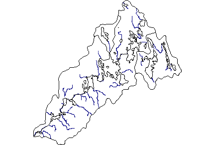
Module 1: Information collected during the introductory stream habitat survey for stream A to M. Information includes directions to the stream, start and end points, landmarks and important features. Please click here to view the data from Module 1. Module 2: Information collected during the advanced habitat surveys for streams C, E, G and H-K. Information includes benchmark location, cross sectional survey, stream discharge, longitudinal survey (measurements and habitat quality) and habitat assessment. Please click here to view the datasheet used in Module 2. The pH monitoring of various locations throughout the watershed The pH monitoring of various locations as it travels down the watershed Module 4: Information collected during the stream invertebrates survey for streams A, C, G and K). Information includes identified families, invertebrate density, abundance, water quality assessment, predominant taxon, diversity assessment and a site assessment rating. Please click here to view the data from Module 4. This document is not available - DP, Oct. 31, 2010. Module 11: Information collected during the juvinnile fish trapping and identification for streams A, F, Cranberry Lake and Fredrick Lake. Information includes, species identification and length.
Back to the WRWEO home page. | |||||||||||||||||||||||||||||||||||