HISTORICAL VISION STATEMENT AND STRATEGIC PLAN FOR THE WOODENS RIVER WATERSHED
26 April 2009
This vision statement and action plan is understood to be a dynamic document that is subject to challenge and revision through public feedback. Please send comments or a copy of this document with track-changes by using the contact link on the website of WRWEO Woodens River Watershed Environmental Organization www.wrweo.ca We encourage your suggestions and intend to respond to suggestions in a timely manner.
OVERVIEW
The Woodens River Watershed covers an area of approximately 65 square kilometers on the Chebucto Peninsula, in Nova Scotia, 20 kilometers west of Halifax. The outflow of the Woodens River is at St Margaret’s Bay, 20 kilometers to the south west of the headwaters. As can be seen from the map, the watershed includes all the land that drains into nineteen connected lakes flowing from their head waters in the area where Hwy. 103 crosses Cranberry Lake (at Exit 4) southwest into the Woodens River and finally into St. Margaret’s Bay at Woodens Cove in Seabright. The lakes include Upper and Lower Sheldrake Lakes, Frederick Lake, Five Island Lake, Hubley Big Lake, and Albert Bridge Lake.
WOODENS RIVER TODAY
The Watershed comprises: undeveloped public (Wilderness Protected Area, Crown, and Municipal) and privately owned lands, which provide a natural habitat for indigenous wildlife and are suited for recreational use; land being used to support forestry-harvesting; as well as privately owned land being used for residential purposes. There is practically no land within the Woodens River Watershed being used for agricultural purposes at this time.
The upper watershed includes several residential communities with access to the city along Highway 103; the central watershed, which includes large tracts of Crown land and is only sparsely populated; and the lower watershed which includes land forestry holding on either side of Woodens River as well as residential settlement along the coastal portion of Highway 103, from French Village, past Seabright, and leading to Peggy’s Cove.
By and large residents of the upper watershed are well served by local schools and churches as well as social amenities including medical and commercial facilities as well as an RCMP detachment in nearby Tantallon. They also enjoy easy access to Halifax along Highway 103 although there is a need for an express bus service and car pool parking to facilitate commuting. By comparison, residents in the lower watershed have fewer amenities but seem satisfied with a rural lifestyle, although there is need for upgrading of Highway 103 to accommodate heavy tourist traffic to Peggy’s Cove. Many residents throughout the Woodens River Watershed are avid outdoor recreational enthusiasts, who enjoy hiking, canoeing, skiing as well as fishing, birdwatching, and nature walks in the unspoiled wilderness area. Most of this natural wilderness lies on the granite barrens and in the wooded areas on the public lands between Woodens River and Nine Mile River further east, but it also includes Long Lake Park just to the north of Highway 333.
HISTORY
Numerous, small piles of rock chips can be found on a few sites in the rockland barrens. These may be the result of early campfires or possible the signs of indigenous people who hunted caribou here hundreds of years ago.
However, the first recent settlement between Timberlea and Lewis Lake was established in 1841 by Alexander Hubley. Indeed, Seabright, which lies at the foot of old Halifax Road, dates back to even earlier settlement by the same family and was once known as Hubley. The hotel he built on the old coach road became known as Fourteen Mile House and many prominent men stayed there while hunting or fishing in the local lakes, which were renown for their thriving trout population.
Crossing the watershed, the Old St. Margaret’s Bay Road, also known as The Old Halifax Road, was a vital transportation link between Halifax and St. Margaret’s Bay in the early years of the province. A map of the interior of Nova Scotia, drawn by Titus Smith in 1801-02 clearly identifies the old road and also shows St. Margaret’s Bay as being called Charlotte Bay. The road was constructed prior to 1800. In 1855 the Old Halifax Road is shown as being located on the north side of Woodens River and is now referred to as Woodens River Road.
NATURAL HABITAT
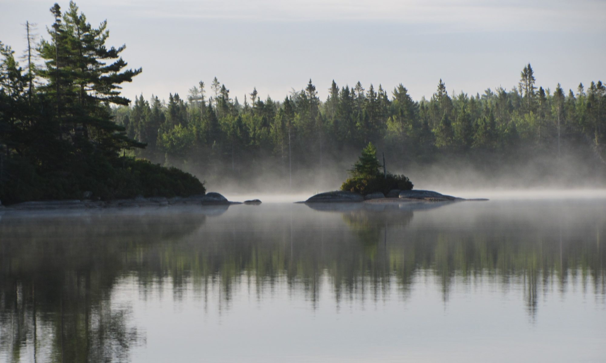
The Woodens River Watershed generally comprises wooded areas around the lakes and along the river, with some notable rock barrens, wetlands, and upland bogs just to the east. With the exception of the lower watershed, the wooded areas and granite barrens have little commercial value, although they do contain some old growth forest stands, rare plant species, as well as significant wetlands and wildlife habitat.
The granite rock barrens immediately to the east of Woodens River are covered with colonies of lichens and dwarfed shrubs and herbs, products of a frequent fire cycle which provided many ericaceous and other species with the opportunity to occupy hundreds of acres. These species include specimens of Mountain Sandwort (Arenaria groenlandica) which is yellow listed for Nova Scotia and healthy populations of broom crowberry (Corema conradii), an important Atlantic Coastal Plain species threatened outside of Nova Scotia and declining due to habitat loss within the province. Water levels, which can change dramatically during the summer months, also provide coastal plain lakeshore species with some suitable habitat. Small pockets of peatland are home to dwarfed forests of spruce (including some black spruce less than 3cm in diameter over 100 years old), pine, maple, poplar and birch while hills of deeper soil provide old oak trees with the nutrients to maintain their dominance. Bogs, raised bogs and fens are scattered throughout the barrens.
The wildlife (Animalia) of the area is typical of most Nova Scotia wild lands, including white tailed deer, beaver and hare, but is remarkable for its black bear and a subpopulation of mainland moose. These moose are indigenous and distinct from the Cape Breton moose, which were established by reintroduction of moose from Alberta in the 1940s. Moreover, the mainland moose are protected under the Endangered Species Act. Protecting this large area and keeping roads to a minimum within it is likely crucial to this population’s survival. These moose could be instrumental in helping preserve the NS lineage by cross breeding with the other indigenous herds facilitated by the creation of wildlife corridors as envisaged in the Regional Plan.
Many small caves are present providing hibernating species of mammals wintering areas, and the reduced snowfall accumulation, compared to inland Nova Scotia, provides many species with an abundance of exposed winter food such as persistent grass seeds and berries.
Pileated woodpeckers are among the many birds that make this area their home. Garter and green snakes live throughout the area along with red-backed and yellow-spotted salamanders. Finally, the favourable fish habitat in Woodens River and its lakes, which may be attributed to the underlying geology, has recently seen a remarkable recovery in the once prolific population of native brook trout together with waterfowl, loons and beavers.
OUTDOOR RECREATION
The proximity of this natural wilderness area to Halifax, Nova Scotia’s largest population center is a gift to those who enjoy the natural environment. The trails provide an opportunity for a true wilderness experience twenty-minutes from the core of the city. The scenery is spectacular, especially during spring flowering of shadbush and rhodora at edges of bogs and lakes, and during leaf color changes in the fall. In the bogs and barrens, a variety of flowering species including native orchids, pitcher plants, and a dozen or so ericaceous species provide a mosaic of colours from spring to mid-summer. Blueberries and huckleberries produce fruit in abundance in August and September, and their leaves provide brilliant shades of red over the barrens from late September to mid-November. The area is rich in wildlife and provides excellent opportunities for viewing in their natural habitat.
For those who enjoy hiking and nature watching, the stacked loops of The Bluff Wilderness Hiking Trail, built, operated, and maintained by local resident members of WRWEO, are readily accessible and the vistas include wide-open spaces and spectacular view planes. In addition, The Bluff Trail forms a natural link between the Trans Canada Federation Trail, and the Coastal Waterway through a series of portages down to Seabright.
Lakes and small streams dot the landscape. Nine larger lakes provide relief from hot summer days and contrast the barren environment with their blue surface and granite spotted shoreline. The lakes are shallow and, like the barrens, are littered with erratics. For this reason, they must be canoed with care and are not suited for motor boats. However, they do afford swimming opportunities much earlier in the spring than many deeper, cooler lakes elsewhere in the province. Beyond the intrinsic wilderness values, consideration of city expansion, population growth and the appeal of eco-tourism warrant protection of this pristine natural habitat for recreational use.
Residents of the watershed are collaborating with the Safety Minded ATV Association to minimize conflict between low impact recreational activity and motorized access as well as strictly regulated use of motorized trails for use by recreational vehicles.
ENVIRONMENTAL IMPACT OF DEVELOPMENT AND OTHER LAND USES WITHIN THE WOODENS RIVER WATERSHED
The relatively high density residential development on the lakeshore near the headwaters of the Woodens River Watershed, tapers off to a tract of Crown land which surrounds Hubley Big Lake, Long Lake and Croucher Lake in the middle of the watershed. This high-density residential development has had a significant adverse impact on the water quality in the upper lakes of the watershed, although the lakes downstream from Hubley Big Lake have not been seriously affected as yet.
Further downstream, there have been commercial forestry operations along the shores of Croucher Lake and Albert Bridge Lake. Failure to comply with forest harvesting regulations in the conduct of some of these earlier logging operations has led to the destruction of the natural buffer zones along parts of the river bank in this region of the watershed. More recently, logging rights to a large tract of privately owned land, down watershed from Millyard Lake, have been sold to a local company giving rise to concern that the exercise of logging rights without due regard for the environment could have a serious adverse impact on the ecosystems in the immediate vicinity. In this regard, it is unfortunate that logging activities on privately owned land remain largely unregulated, although Guidelines are available.
Still further downstream, there is low-density residential development of the privately owned land at the southwestern extremity of the watershed where Woodens River enters St Margarets Bay. Some of the land in this region has been sub-divided into long narrow strips in bequests over past generations and so could still be suited for forest harvesting but would require consolidation to permit even low density residential development. Nevertheless, the natural environment in this region appears relatively unscathed by current levels of development.
All of these land-uses impact on the quality of the environment within the watershed. This notion is recognized in the HRM Water Management Strategy, which calls for use of the watershed as a management unit and recognizes the linkage between land use and the future of the water resource, as well as in the HRM Regional Plan which states that development must be constrained by the assimilative capacity of the nearby water bodies.
Noting that HRM has already approved residential development of several hundred additional waterfront properties in the upper watershed it is apparent that the assimilative capacity of these upper lakes will be heavily taxed when the associated septic fields saturate the surrounding soil and combine with fertilizer run off to add to the nutrient load. These considerations are also vital to the health of the natural environment down watershed since fully half of the excess nutrients tend to be flushed downstream
COMMUNITY INVOLVEMENT AND IDENTITY
The residents of the Woodens River Watershed include the relatively recent residential communities around the upper lakes, together with the older settlements in the lower watershed which were originally dependent on forestry and fishing but have given way to residential and small business development, heavily dependent on the tourist trade.
Notwithstanding these differences, over the last fifteen years many of the residents have displayed a high level of community spirit and volunteerism in forming several community-based environmental groups (including WRWEO, FBWHT and SMBSA) to protect the natural environment. While recognizing that some development is inevitable, local residents are determined to continue working with government to ensure that future development within our watershed is not permitted to despoil this unique legacy to future generations.
COMMUNITY BASED ENVIRONMENTAL ORGANIZATIONS
Most of the residents of the watershed share an abiding concern for the natural habitat, and the citizens of Halifax are indeed fortunate to have a major natural wilderness area so close to downtown. This concern for the natural habitat led to the formation of the Woodens River Watershed Environmental Organization in 1995 following a PCB spill into Five Island Lake, the threat of further development through a trade of crown land, and a series of studies which indicated nutrient levels in Sheldrake Lake were some five times greater than the natural levels in nearby undeveloped lakes in the upper watershed.
Seven years later two other community groups, with somewhat more ambitious objectives but similar environmental concerns were established. These were The Five Bridges Wilderness Heritage Trust and the St Margarets Bay Stewardship Association. The much larger mandates of the later two community groups both included the entire Woodens River Watershed and all three organizations have been collaborating closely ever since, in working with government to ensure orderly development without prejudice to the environment.
In the upper watershed these endeavours enjoy close support by the local homeowners associations, while residents along the coast near Seabright have assumed leadership roles in initiatives such as the Council of Community Organizations, better known as COCO, which was formed in 2002 to share information between like minded community based-organizations throughout the western portion of Chebucto Peninsula. More specifically,
COCO is intended:
Ä to facilitate co-operation to deal with issues of common interest
Ä to increase the likelihood that groups can negotiate from a position of strength, and
Ä to reduce the opportunity for groups to be played off against one another, by providing them with opportunities to share their expertise in lobbying government agencies or departments in order to accomplish goals of benefit to the community at large.
It should be noted that the Council does not have any decision-making powers but rather operates with the objective of sharing information and providing the opportunity for frank and open discussion.
In this regard, residents have been working closely with government over the last eighteen months to develop a template for planning for use of the public lands on the Chebucto Peninsula. On March 28, 2007, the Five Bridge Wilderness Heritage Trust approved the Chebucto Peninsula Stewardship Charter (reprinted in the January 2008 edition of The Bridge) for the management of public lands and waters on the Chebucto Peninsula in a way “that conserves and improves ecological integrity and ensures sustainable use”. This Chebucto Peninsula Stewardship planning endeavour was initiated by the Five Bridge Wilderness Heritage Trust some seven years ago and was originally intended to give the opportunity for planned and meaningful participation by community groups with government in the planning process. In September 2005 DNR Deputy Minister Peter Underwood formed a Working Group including leaders of volunteer organizations in the area to develop a model for collaborative planning and management of the public lands on the Chebucto Peninsula. The initiative responded to four years of work by FBWHT to establish a framework in which three levels of government and community representatives could participate. Unfortunately, the outcome of these endeavours has been a bitter disappointment to the volunteer participants.
In a letter from the Deputy Minister, Department of Natural Resources (November 2, 2007), the members of the Working Committee are thanked for their time, energies and thoughtfulness in their work together over an eighteen month period. However, while the Deputy Minister makes reference to the Charter and the principles being endorsed by Department and states that they will be used in ongoing planning and management of Crown Lands both on the Chebucto Peninsula and other parts of the province, he fails to give any indication of any process by which the planning will take place or how the principles will be incorporated into future planning. In response FBWHT asked to clarification in a letter of November 27 and in February 21, 2008, Mr. Underwood replied that “DNR will not be undertaking any further work with regard to the Chebucto Peninsula Working Group, or reviewing/establishing structures or models for land use management and/or community input while the Natural Resources Strategy process is underway (2008-2010).”
Under these circumstances, while all of these community- based organizations welcome the development of a long range Regional Plan, and the supporting community Vision and Strategic Action Plans, there is a concern that development could outpace the introduction of controls and guidelines to protect the natural environment.
Consequently, at its AGM in March of 2008 WRWEO unanimously passed a resolution to develop and carry out a strategy to protect under the 1998 Nova Scotia Wilderness Areas Protection Act the 9,800 hectares of public lands within the boundaries of Highways 103 and 333 in the County of Halifax and to join a coalition of community groups interested in pursuing the same end. FBWHT passed a similar resolution shortly afterward and the Chebucto Wilderness Coalition was then formed under the leadership of WRWEO and FBWHT. It now comprises over 35 organizations, including not only environmental groups but also residential association, recreation groups, businesses, and even developers. In June 2, 2008, the proposal for protection was presented by the late Dr. Wilfrid Creeigton and CWC to Mark Parent, Minister of the Nova Scotia Department of Environment. It has since received the support of HRM Regional Council, the local MP and MLAs, the Liberal and NDP caucuses, and the Nova Scotia Department of Natural Resources. (A brochure with a map of the area and a list of supporting organizations is attached.)
The formation of this broad coalition and the subsequent political backing reflects the determination of local residents to preserve and protect the natural environment within these public lands, including the Crown Land in the Woodens River Watershed, on the grounds that:
Ä It constitutes a magnificent natural wilderness area within reach by public transportation from the major population center of Atlantic Canada,
Ä It has the potential to provide residents and tourists with easy access to a true wilderness experience, for generations to come,
Ä It provides a unique opportunity for a variety of low impact outdoor recreational activities (i.e. those consistent with the Wilderness Protection Act such as ‘Leave no Trace Camping’ ), and
Ä It can serve as a prime candidate eco-tourist destination
Ä It provides an important resource for scientific and historical study given its proximity to universities and schools. On The Bluff Trail alone over 100 species of lichen have been discovered.
Ä Although most of the lakes and streams remain relatively pristine at this time and support healthy brook trout populations, the stability of these brown water, low pH systems is highly dependent on maintaining the integrity of the natural landscapes as much as possible.
PLANNING CONTEXT
The Environmental Goals and Sustainable Prosperity Act commits the province to protecting 12 per cent of Nova Scotia’s land mass by 2015. Recent approval for the Blue Mountain-Birch Cove Lakes Wilderness Area will help meet that provincial goal.
The public lands within the Woodens River Watershed are ideally situated to form a natural wildlife corridor linking the Blue Mountain Birch Cove Lakes Wilderness Area to the Western Commons Wilderness Area in keeping with the Regional Planning Strategy which calls for creation of a regional park in the area. Such an enlarged Wilderness Area would protect numerous interconnected, undeveloped lakes and wetlands; rugged woodlands with old red oak and black spruce stands; and a rare arctic-alpine plant species. It would also help protect the natural habitat for wildlife including the endangered moose herd. Moreover, it would provide exceptional outdoor education and wilderness recreation opportunities such as hiking, swimming, cross-country skiing, canoeing and angling.
At the same time The Bluff Wilderness Hiking Trail immediately to the east of the watershed lies at the confluence of the Trans Canada Trail, the Beechville Lakeside Timberlea Rails to Trails and includes portage routes linking to the Atlantic Coastal Waterway. Further downstream there are some land forestry holdings on both sides of Woodens River and limited residential settlement along the coastal portion of Highway 103 from French Village, past Seabright, leading to Peggy’s Cove.
Residents within the Watershed are united in their resolve to protect and preserve the natural environment while developing a range of opportunities for outdoor recreation and eco-tourism.
ACTION PLAN
The actions listed below are necessary to achieve the Vision developed by residents for the future of the Woodens River Watershed. The Strategy and Action Plan are organized under the main themes that have been identified in the HRM Visioning process and take into account contents of the earlier Watershed Management Plan, developed by the Woodens River Watershed Environmental Organization and published in 1998, as well as the subsequent planning initiatives by the Five Bridge Wilderness Heritage Trust and the St Margarets Bay Stewardship Association, working with the municipal government to implement the HRM Regional Plan and with Provincial authorities to develop a Strategic Planning Framework to govern development on the Chebucto Peninsula.
More detail of these initiatives can be found on their respective web sites:
WRWEO www.wrweo.ca
FBWHT www.fivebridgestrust.ca
SMBSA www.heartofthebay.ca
Natural Environment
Goal #1
Preserve and protect the natural habitat within the Woodens River Watershed for generations to comeActions
1. Enact legislation to preclude against any further sales or swaps of Crown lands within the Woodens River Watershed for residential or commercial development, including resource extraction.
2. Encourage government agencies at both the Provincial and Municipal level to purchase any private lots necessary to connect the Crown lands and create the natural wildlife corridors envisaged in the Regional Plan.
3. Collaborate with other NGO’s, such as the Nature Conservancy and the NS Nature Trust to promote bequests of privately owned land for inclusion in the Woodens River natural wilderness area
Goal # 2
Noting that nearly all human activity has an impact on water quality, regulate all development in a manner such as to mitigate any adverse impact on water quality within the watershedAction
1. Residential Development
Limit lakeshore residential development in the upper watershed to density levels that are within the capacity of the receiving water body to absorb nutrients from septic tank effluent and fertilizer run off from lakeshore residential development and encourage landscaping techniques not dependent on heavy use of fertilizer, especially phorphorus.
2. Recreational Development
Limit recreational development such as golf courses or marinas on the same basis
3. Sewage Treatment
Demand tertiary sewage treatment facilities for any proposed high density residential developments or public facilities such as schools
4. Buffer Zones
Protect a 30 metre natural buffer zone of undisturbed vegetation along all lakes and river-courses.
5. Enforcement
Rigorously enforce existing legislation to protect the environment, including prosecution of violations, rather than merely warning transgressors not to repeat their offences
6. Public Education
Promote environmentally responsible development of private land holdings within the Woodens River Watershed Management Plan.
Outdoor RecReation
Goal #1
Develop and expand outdoor recreational opportunities which have a minimal impact on the natural environment
Actions
1. Maintain and operate The Bluff Trail for Hiking and Skiing
2. Ensure that WRWEO continues to receive adequate funding to contract out for regular trail maintenance
3. Provide an interpretation center and sign in registry at the entrance to the trail system
4. Promote Leave No Trace campingGoal # 2
Preserve and enhance outdoor recreational opportunities at Long Lake Park,
taking care to protect the natural environmentActions
1. Develop trails to link Long Lake Park to the proposed Wilderness Commons and The Bluff Trail provided that any trail providing access to The Bluff Trail are for hiking and skiing only and not for use of OHV or mountain bikes
2. Facilitate year round public access to Long Lake Park by provision of parking and public transport
2. Groom the cross country ski trails within the park during the winterGoal # 3
Encourage Canoeing and Kayaking within the Watershed
Actions
1. Reopen and maintain the portage route linking Hubley Lake down to the Coastal Waterway at Seabright
2. Maintain the portage routes recently re-opened linking Cranberry Lake to Frederick, Five Island, Upper, Middle, and Big Five Bridges Lakes, Moore, Twiddling, Shad Bay Lakes, and the Shad Bay.
Parks and Public Lands
Goal #1
Preserve and protect the public lands within and adjacent to the watershed as a natural wilderness area, including the public lands bounded on the south by Highway 333, on the east by the Nile Mile River, on the west by the Lewis Lake fire road (beginning at Joshua Slocum and meeting the Old Coach Road near Big Five Bridges Lake, and on the north by Highway 103 and residential communities of Lake of the Woods, Cambrian’s Cove, Three Brooks, and Birth Cove. We refer to this block of some 9,800 hectares as the “Chebucto Wilderness” since it contains the largest block of contiguous public land on the Chebucto Peninsula. The Chebucto Wilderness Coalition (CWC)ãsee description aboveãwas formed almost a year ago to protect this land through the 1998 Nova Scotia Wilderness Areas Protection Act. CWC now includes over 35 supporting organizations, including WRWEO, and has been unanimously endorsed by HRM Regional Council, the local MLAs and MP, and has recently received preliminary endorsement by NSDNR. The next stage is for NSDE to designate it as a Candidate Protected Area.Actions
1. Seek NSDE action to designate these lands as a Wilderness Area under the Wilderness Areas Protection Act in keeping with the Provincial commitment to the creation of protected areas
2. Pursue the HRM Regional Strategic goal of creating another park in the watershed region
Wind and Geothermal Energy
Goal #1
Support HRM’s initiative to provide a transition to renewable energy source of wind and solar power in a manner consistent with balancing relevant environmental and other values.
Actions
1. Develop a well thought out plan for locating wind towers that takes into account the value of wilderness preservation as well as esthetic and recreation values, all of which are exemplified in the Blue Mountain Birch Cove Lakes Area, HRM’s Western Commons Wilderness Area, and The Bluff Trail Wilderness Area.
2. Provide extensive and effective public consultation as well as expert study before any decision is made about the location of wind towers and encourage geothermal construction in new buildings and methods for capturing geothermal energy through renovation of old buildings.
Infrastructure
Goal #1
Provide residents of the Watershed with an efficient public transportation system to reduce the use of private motor cars and reduce their carbon imprint
Actions
1. Establish an express bus service between Exits 4 and 5 on Highway 103 and downtown Halifax
2. Provide a commuter parking facility at Exit 4
3. Provide more frequent bus service between Seabight Tantallon and Hubley to enable residents access to public facilities such as the Library, RCMP Station and St Margarets Bay Arena
4. Improve Highway 333 from Exit #5 to Peggy’s Cove to accommodate tourist traffic including passing lanes and lay bys.
Aesthetics
Goal # 1 Minimize the visual impact of human development on the natural environment
Action
1. Encourage environmentally sensitive development of lots already approved for development by covenants to set back and minimize the footprint of new dwellings, preserve natural ground cover, and discourage lawns and large gardens. (This action will reduce impact on water quality and wildlife.)
2. Encourage developers of lots already approved to set aside green spaces and provide public access to lakes and waterways
3. Discourage the use of street lights in new residential communities, noting that intermittent lighting is more conducive to criminal activity than none at all.
4. Regulate against the use of bill board advertising within the community