 Even if you have a GPS, you should be able to describe where you are and to navigate using only a map and a compass.
This set of videos were produced in the summer of 2014 to aid in the teaching & learning of basic map & compass skills with special reference to The Bluff Wilderness Hiking Trail. The videos were developed for kids ages 8-9 and up (also available to adults!). It is assumed that users are familiar with concepts of latitude and longitude, north and south poles, magnetic north, true north. (See Web Resources below for more on those and related topics.)
Thanks to Kai and Sascha P., Richmond C., Steve F. and David P. Feedback welcomed. Please send that to info@wrweo.ca.
THE VIDEOS

Where are we? (2 min)
Richmond describes why it’s important to be able to give the grid co-ordinates for your location.
Grid Coordinates (4.5 min)
Kai and Sascha learn how to determine the grid coordinates.
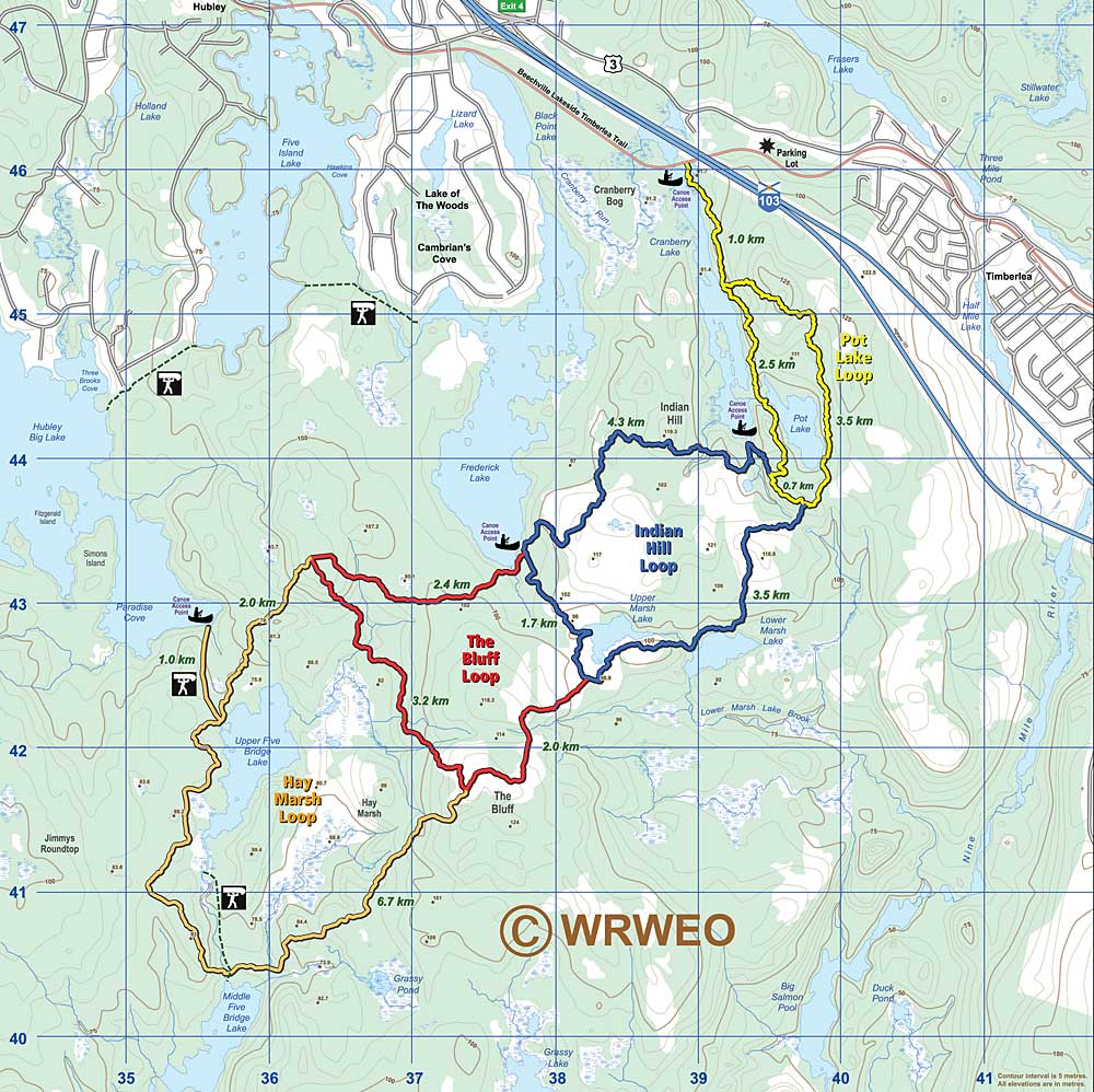
Whats on the map of The Bluff Wilderness Hiking Trail (12 min)
Richmond describes the grid system, the trails, contours, colours and symbols.
View Map
Triangulation (9 min)
How to find out where you are, even if you are off-trail but have a map and a compass.
compass
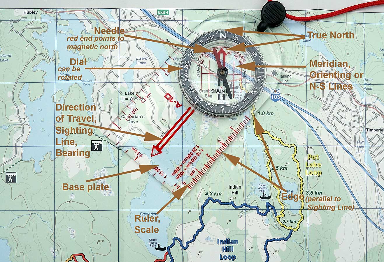
Triangulation – review (8 min)
A review, with labelled maps, of the triangulation process.
Orienting the Map (4 min)
We’re on a small but spectacular “mountain” in the Backlands of Halifax south mainland. Kai shows us how to orient the map so that we can relate what we see on the map to what we can see on the land.
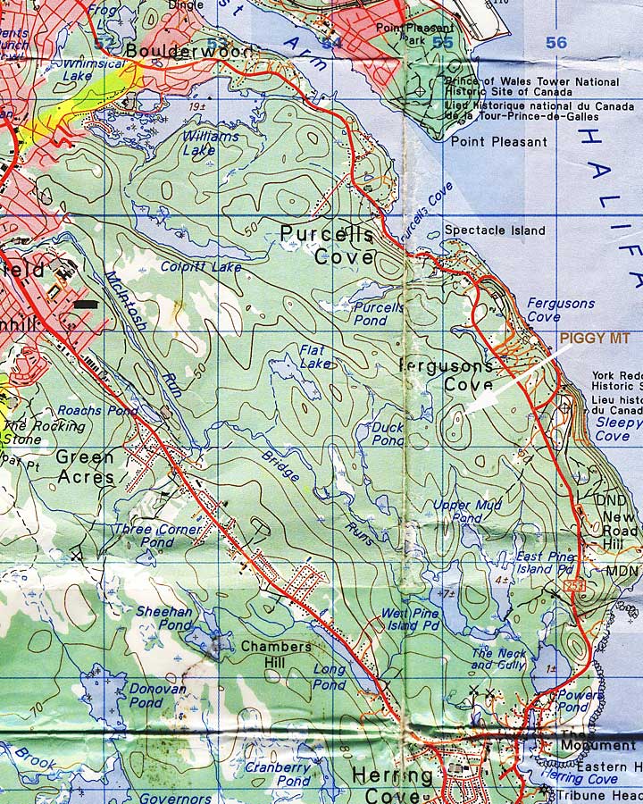
Navigating with Map & Compass (5 min)
We are on Piggy Mountain and we want to go to Williams Lake. We can’t see it, but it’s on the map, so we can still figure out how to get there.
Using the Sun to tell Direction (5 min)
Steve shows us how to use a stick and the sun to determine direction.
- Basic Map & GPS Skills
32 page pamphlet by the National Geographic Society on how to read a topographic map, use a compass, and determine GPS locations on a map. - Magnetic Declination
Natural Resources Canada page - Instruction manual for Silva Ranger Compass
16 page pamphlet explains basic functions of the compass - Using a Garmin GPS with paper maps for land navigation
40 page Garmin pamphlet. - Using a Sundial
School or home activity. A BioEd Teacher Resource from the Center for Educational Outreach at Baylor College of Medicine.

Map and compass days on The Bluff Trail
Girl Guides & Pathfinders on The Bluff Trail
 May 10, 2014: WRWEO Board members lead a Wilderness Workshop for the 1st St. Margaret’s Bay Guides & Pathfinders on The Bluff Trail. The girls learned map skills & to identify some native plants and we talked about “Wilderness” and what it means to us. We all learned a lot! View Pics
Family Day on The Bluff Trail
July 19, 2014: Five Families with youngsters participated in this WRWEO-sponsored, Nova Scotia Park Event lead by Nanci Lee and David Patriquin, Co-chairs of WRWEO. We were joined as well by Troy & Christa with MoMo, Troy’s Seeing-Eye Dog. At the trailhead, participants were given a brief intro. to the ecology of The Bluff Trail, and to using a Map & Compass. Then they set out to search for specific plants at points indicated on a map of The Bluff Trail (“biocaching”)… read more